 |
 |
|
| Log
#9
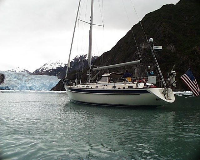
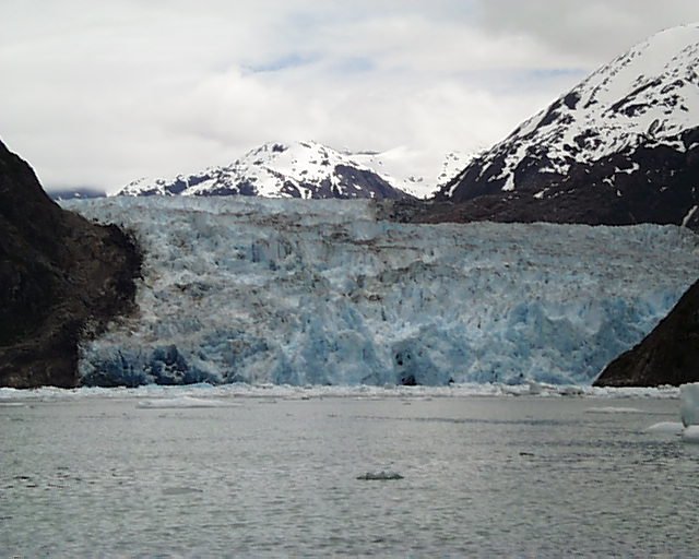
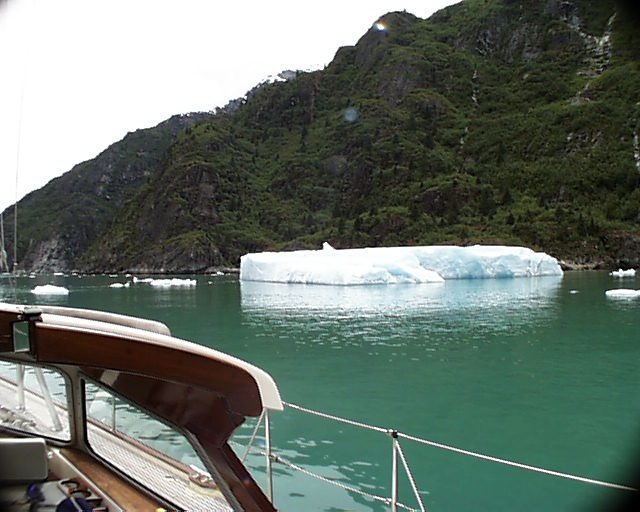
Tracy Arm and South Sawyer Glacier Wednesday June 23rd By 08:15 we're underway from Tracy Arm Cove. Our destination is the head of Tracy Arm where there are two large glaciers: North Sawyer and South Sawyer Glacier. The weather today is reasonably good. Although we have mostly high clouds there are frequent sun breaks, and, best of all, no rain. Immediately after clearing out of the cove and turning northeast I see a whale breach out of the water about a mile away. Tracy Arm is a beautiful fjord with 5000 foot snow capped mountains lining the way on each side. Around every bend we see more and more ice floating in the water. The initial ice we see is large and infrequent, about 60-80 feet long, and sometimes 6-10 feet high--the only pieces sizable enough to survive the 18 mile trip from the glacier. As we wind our way further in, the ice becomes much more frequent, and smaller chunks prevail. After four hours we make our initial approach towards South Sawyer Glacier, which is still two miles to the east. The ice is heavy today, and has formed a blockade across our path; and it doesn't appear that we can get through it. Two other boats, one large power yacht and one sailboat, are holding in front of the ice blockade, which appears to be a solid line of ice chunks across the entire 1/4 mile width of the narrowing fjord. As we hold our position to discuss strategy, several plans emerge. One is to place the outboard motor on the dinghy and take turns motoring into the glacier while one person remains on board to watch the boat. This plan will be safe, but very time consuming. Another plan is to try and thread our way through the ice, with someone on the bow pushing chunks away from the hull with our boat hook. There appears to be too much ice across the blockade to execute this strategy, however. A third plan is to wait for some of the tour boats and literally follow in their wake. We start to get the dingy ready, but move quickly to plan 'C' when four tour boats arrive from Juneau. It appears that these boats make daily trips and are familiar with the ice, so we fall into line behind a large 100 foot boat called the Liseron. With the Liseron leading the way we make fast time through the ice floats, even though Liseron often slows when she encounters large 20-30 foot long floats that she has to thread through. Several smaller power boats that pierced the ice blockade after us have decided to go their own way. But they quickly fall in line behind us as their hulls start banging into ice. Even at slow speeds these icebergs can present a serious threat. And as we've all heard, only 10% of the mass is visible above the water. Liseron takes us to a branch, with the North Sawyer Glacier to the left, and the South Glacier to the right. At this junction the larger boat turns port toward the north glacier. Because we have decided to see the South Glacier, we turn starboard and head off on our own--boldly at first, then somewhat timidly as we discover new challenges. As we continue to work our way in through the ice, we leave a healthy distance between us and the big chunks, now sometimes 100 feet in length and larger, lest we become a mini-Titanic. The guide book says that these larger icebergs can unexpectedly roll over, presenting a potentially dangerous situation to any vessel close by. Within 15 minutes after boldly heading off in our own direction we arrive at another impasse--too much ice to comfortably get through. After a few gentle probes, we stop and discuss the dingy plan again, even though we're still a mile away from the glacier. As we discuss alternate plans, we see a large 80 foot private yacht that is successfully making a return trip back from the glacier. We watch it motor slowly on the south side of the fjord, adjacent to the rock wall, and see that the path is much clearer over there about 1/4 mile to our starboard. So we head that direction. As we approach the south wall we see that a clear path has opened up, so we creep slowly along, adjacent to the rock wall. Even though we're very close to the vertical rock (about 75 feet away), our depth gauge's digital monitor simply displays the word "deep," indicating that the depth is at least 600 feet. At one point I get a solid reading of 720 feet--the equivalent of a 72 story building under our keel. As we continue our approach it's evident that we have to change strategies again, because the path along the south wall ends with rock directly in front of us. We turn 90 degrees to port, and cut across the fjord, threading our way through even denser ice floes. Now we have ice on all sides. Sometimes we must pivot the boat using our bow thrusters in order to avoid collision, although most of the ice chunks are small, only about 2-3 feet in diameter. We are now 3/4 of the way across to the north side. As we slowly drift north, we begin to round the rock wall barrier to the east. As we gain on this point, the last turn, Sawyer Glacier slowly comes into view. Although still 1/2 to 3/4 mile away, it is massive--probably 1/2 mile wide, and 300-400 feet high. Down by the water, at its base, the ice is a deep, deep blue. (Photo: S. Sawyer Glacier 3.)
We turned hard to starboard and motored slowly and delicately in a moving maze of icebergs and bergies. We spotted a clearing ahead to the east created by three other boats that have advanced as far as possible. We joined them and watched the glacier and ice floats constantly moving around us. It was a full-time job to maintain our position and avoid bumps and scrapes, although I confess that we touched a few floaters several times throughout the day. Within 45-minutes of arriving, all of the other boats have decided to leave, so we had the glacier to ourselves. We remained at this farthest point in for another 20-minutes to enjoy the unique serenity of having this majestic location all to ourselves. On two occasions we heard the glacier move. The noise produced by this movement is indescribable. It sounded like an earthquake--an incredibly low frequency rumble from someplace deep inside the ice, lasting only a few seconds. You almost felt the sound before you heard it. As we turned to leave we discovered that all of our previous paths had been blocked by wind and current. But by now we had a degree of confidence and comfort in our ice floe navigating and negotiating skills, so we moved slowly, and just looked step-by-step for the best escape route. Because the other boats had left us half an hour earlier, we had neither guide nor ice breaker to show the way. On occasion we had to stop, reverse, pivot with the bow thrusters, and probe alternate routes. But slowly, we made our way through the ice debris. All around us we noticed dark spots on the ice, which, upon closer inspection, turned out to be seals and their newborn pups. There were perhaps 50 or more. Some of them slipped into the water if they deemed our approach too close. Finally, after about 90 minutes, we were through the worst of it. Several other boats approached from the opposite direction with the intent of getting in. But none of them made it very far. They all stopped at the edge of the ice field that we had just successfully navigated.
Motoring back to our anchorage at Tracy Arm Cove we encountered many more ice chunks along the way than we had on the approach. Many were small and non-threatening. Most were large enough to be a problem, but also large enough to see. A few were even large enough to appear on radar. The worst ones were the surface floaters--large enough to scrape the hull, but low to the water, and colorless (and therefore mostly invisible). The only sign of these was an occasional 'thunk' as the hull made contact. Unfortunately we hit a few of them throughout the day, so I'll have to do a close inspection next time I haul the boat. Arriving at our anchorage we were greeted by a dozen other boats. Slipping around the back of the bay, behind all of the other boats, we found a suitable anchor spot at 18:44. Today we completed a 45 nautical mile round trip. After
dinner we sat in the cockpit and watch, to our amazement, the sky clear
on the southern horizon, and then overhead. Five or six miles south, snowy
mountains turned lavender in the fading sun. It is beautiful beyond belief,
and provides a tranquil ending to a fascinating day. As a side note, these
days now are incredibly long. At midnight it looks like dusk outside,
and at 03:00 bright light streams into the boat. Up Next ... |
|
New Logs | All Logs | Route Maps | Links | Sponsors | What's New | Home | Contact | Search
|