 |
 |
|
| Log
#12
From Juneau to Glacier Bay, anchoring at Reid Glacier Monday July 5th After a morning trip to Gas N' Go to replenish our propane tanks (the cab fare cost twice as much as the propane), we left the intermediate vessel dock in Juneau to motor southeast through Gastineau Channel. Rounding Point Tantallon on the southeast tip of Douglas Island we then headed south towards Admiralty Island, in the hopes of spotting some griz., or grizzly bear, better known as brown bear. The Tlingit (Tribe) word for Admiralty Island was Kootnoowoo, or "fortress of the bears." Admiralty Island is home to more than 1,600 brown bears, which equates to one bear per square mile. This is not the island where you want to row ashore for a picnic. Or to take Fifi for a walk. Without her leash. Or to watch your dinghy drift away because you forgot to tie it off during incoming tide. (I have heard, however, that several boaters have been known to inadvertently leave their mother-in-law behind here.) The scientific classification for brown bears is Ursus arctos, and the subspecies classification is horribilis. I don't know what ursus refers to. I invite those of you fluent in Latin to clue me in. I am guessing that arctos refers to someplace cold and northerly, like Alaska, for instance. Horribilis, on the other hand, refers to something very unpleasant. Male grizzly bears weigh in around 300 pounds, while the larger Alaskan Kodiak brown bear averages 800 pounds. They generally inhabit open areas, including plains and tundra. When active they can eat up to 90 pounds of food per day. You can conclude some very important information from these descriptions: you don't want to surprise one while taking a stroll in the tundra. It would be much better, for example, to stroll in a group. (This brings into effect the axiom of marginal safety: When strolling in a group, and encountering a bear, you don't have to be able to outrun the bear. You only have to be able to outrun the slowest person in the group.) As we head south towards Admiralty Island, the wind perks up to about 15 knots, so we unfurl the sails in an attempt to catch some wind and travel without engine noise. As we draw up parallel to the shore of Admiralty Island, we see no bears, at least for today. Around 15:00 we turn to port around Point Retreat on the northern tip of Mansfield Peninsula, and now head south in Lynn Canal. The weather has turned. We beat into two foot chop under 25 knots of wind directly on the nose. But the pounding is short-lived. By 17:25 we are anchored in Crab Cove within Funter Bay, on the west side of Mansfield Peninsula. It seems logical that Crab Cove would have some crab, so I bait the crab trap with leftover bones from our BBQ rib dinner, and throw in a can of cat food for extra margin. I decide to leave the trap in overnight. Tuesday July 6th Awakening to partially sunny skies, the first order of business is the crab trap. With great excitement, I row out to the trap, haul it up, discover three good size crab, and then row back to the boat to show my comrades. Upon closer inspection at the boat, all three specimens prove to be females, and so back into the Crab Cove they go. All of them try to pinch me as I pull them from the trap. If they only knew what a favor I was extending to them. We are underway by 10:30 accompanied by increasingly sunny skies. Only 1/4 mile northwest of Station Island, directly outside of Funter Bay, a humpback whale surfaces directly to starboard. He is about 50 feet away, running parallel with Andanté's course. His long curved back and small dorsal fin slice silently and effortlessly through the water as he surfaces for air, and explodes a column of mist as he exhales. We cut the engine to entice more attention from him, but he disappears after his second dive, only to surface five minutes later over 1/2 mile to the south. South of Point Couverden, on Couverden Island, the wind picks up. We sail with full main and genoa under blue skies with 12 knots of wind. Sailing southwest into Icy Strait, we tack north to the Sisters Island at 58º 09.52 north, and 135º 14.89 west. During our sail, a call to Glacier Bay confirms our permit, but also opens up the opportunity for us to enter the park and complete the orientation this evening instead of tomorrow, which we decide to take advantage of. A few quick navigation calculations inform us that we will not be able to arrive at the park this evening under sail based on current course and speed. So, with reluctance, we furled the sails and fired up the diesel. It's a long run to Bartlett Cove, and we arrive at 18:45, in time to complete our orientation. Total distance for the day: 51.7 nautical miles. Our orientation consists primarily of a packet of information with the sound advice "read this later," and a ten minute video. The video includes too much detail to remember at first pass, and so the ranger finds us rewinding the tape at several intervals, whereupon we are told "everything is in the information packet." So the purpose of the video, clearly, is not to communicate information, but rather to simply have a nice looking video. But perhaps I'm expecting too much from the park service. The information packet includes significant detail about the number of land ecosystems (five), the number of marine ecosystems (three), the importance of keeping pets on a leash (very), and the need to check your firearms--presumably because several boaters have, in the past, become angry at not being allowed to rewind the video, and have leveled their firearm on the closest ranger. This behavior is now clearly verbotten. But I digress. Useful information in the information packet, such as the recommended anchorages throughout the park, isn't provided. So, valuable information is gleaned only by asking the ranger pointed questions that can't be answered in 'yes' or 'no.' We are also free to copy the recommended anchorages onto a black & white photocopied map from a poster on the wall. The system works. Thursday July 8th - Glacier Bay Glacier Bay is one of the largest 'units' (government speak for 'park') in the National Park System. Designated as a national monument in 1925, it was reclassified as a national park and preserve in 1980. In 1986 UNESCO named Glacier Bay as a Biosphere Reserve, and in 1992 it was listed as a World Heritage Site. The geological history of this area, defined primarily by earthquakes and glaciers, reaches epic proportions. The Lituya Bay Earthquake on July 9th 1958 caused Fairweather Fault to shift northwest about 21 feet, which begat landslides which created a giant 1,700 foot wave. By comparison New York's World Trade Centers One and Two, the tallest structures in the world, are 110 stories high. Add 60 more stories on top of the Trade Center and you get to 1,700 feet. Stand at the bottom and look up, and you get the idea: this was the Big Kahuna. Changes in area glaciers have been equally dynamic. In 1794, Captain George Vancouver's cartographer recorded Glacier Bay starting just four miles off of Icy Strait. When John Muir created the next map 85 years later in 1879, the glacier had retreated over 35 miles. Grand Pacific Glacier retreated so far that it retracted across the border into Canada. Today, however, most of the park's glaciers are either stable or advancing. Grand Pacific Glacier has advanced two miles since 1920, and its terminus has advanced back into the U.S. Margerie Glacier has remained stationary for several years, but is now colliding with the Grand Pacific Glacier. Johns Hopkins Glacier has advanced steadily for 60 years.
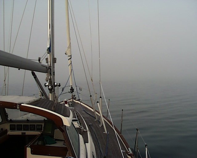
The currents through the entrance to Glacier Bay at Sitakady Narrows, which can exceed eight knots, dictate that we arise early this morning to pass through at slack, and so we are underway by 6:45. The sun is shining above, but we are ensconced in a thick fog, which obscures all possible reference points. We navigate only with electronic instruments, by GPS and radar. Once the fog burns off, the day turns glorious and the scenery magnificent. I can't adequately describe what we see. As we float along northwest in Glacier Bay's main arm--towards the park's most prominent tidewater glaciers: Reid, Margerie, and Grand Pacific--we find ourselves in a natural cathedral of sorts, defined by snow-capped mountainous walls, turquoise blue water underneath, and crystal clear sky overhead. Our weather is also a miracle. July is mostly a rainy month in Alaska, but today is sunny and warm. By noon, we're down to t-shirts. Everyone aboard professes that this is one of the most spectacular places we've ever been, but we all know that the words fall short of describing the experience.
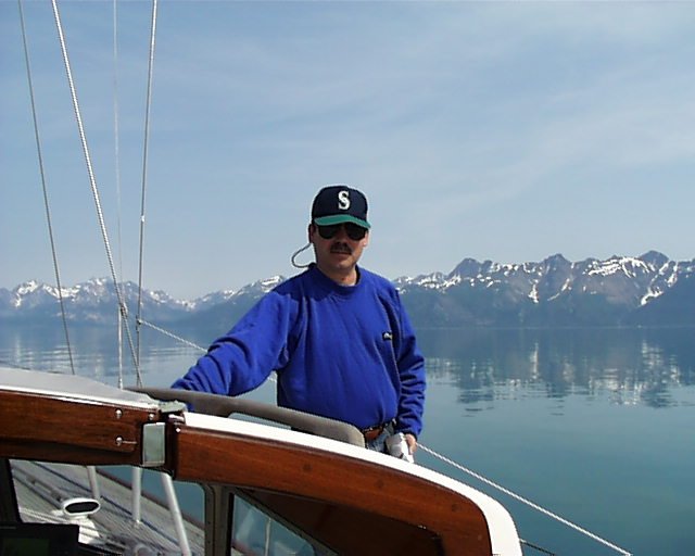
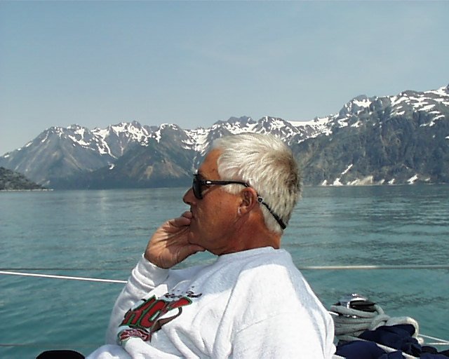
We aim for an anchorage at Reid Glacier, and arrive at 17:00. The oblong bay extends about two miles south from the main channel. The approach to the entrance is choked by an exposed shoal flanked by rocks extending from the west, and a submerged shoal from the east. We enter slowly and carefully. Once inside, two things grab our attention: Reid glacier, nine miles long, 750 yards wide at waterline, deep blue and snow white, looms up 100 feet or more at the south end of the bay. And also the wind, which rips through our little bay at 20 + knots. A semi-protected area just south of the exposed shoal looks like a great spot, and so we make our customary slow cruise around the area to probe the depth with our depth sounder. Everything is deep. We hail one boat that has already anchored to find out how much rode he has out, and whether it's chain or nylon. The skipper responds immediately and answers our questions in detail, but concludes by saying "I don't know where you're going to go." Nothing like a helpful pessimist to brighten your day. After perhaps 30 minutes of probing, we select a drop spot equidistant from the exposed shoal to the north, and the already anchored boat to the south. The drop spot lies on a narrow bar only 60 feet below, while the remaining area around us scans in at about 100 feet. In addition to giving us a more shallow anchorage, the bar affords us with adequate swing room throughout the night. By 17:30 Andanté's CQR (pronounced SEcure), has dug in. (Photo: Jon & Dave, Reid Glacier.) Throughout the night, Reid thunders and booms. Access & Resources Should you be interested in planning a trip to Alaska, and would like to see brown bears in the wild, you can watch them at the Pack Creek Bear Viewing Area 28 miles southwest of Juneau where they catch and feed on salmon. The forest services charges $50 for each visitor (the bears take a percentage). You can download a permit application from the Internet for the Pack Creek Bear Viewing Area at www.fs.fed.us/r10/tongass Find out more about Glacier Bay at www.nps.gov/glba/ or send e-mail to glba_administration@nps.gov Or contact them via snail mail at: Glacier
Bay Nation Park and Preserve Tel.
907/697-2627 (April through October), or 907/697-2230 (November through
March). Up Next ... |
|
New Logs | All Logs | Route Maps | Links | Sponsors | What's New | Home | Contact | Search
|